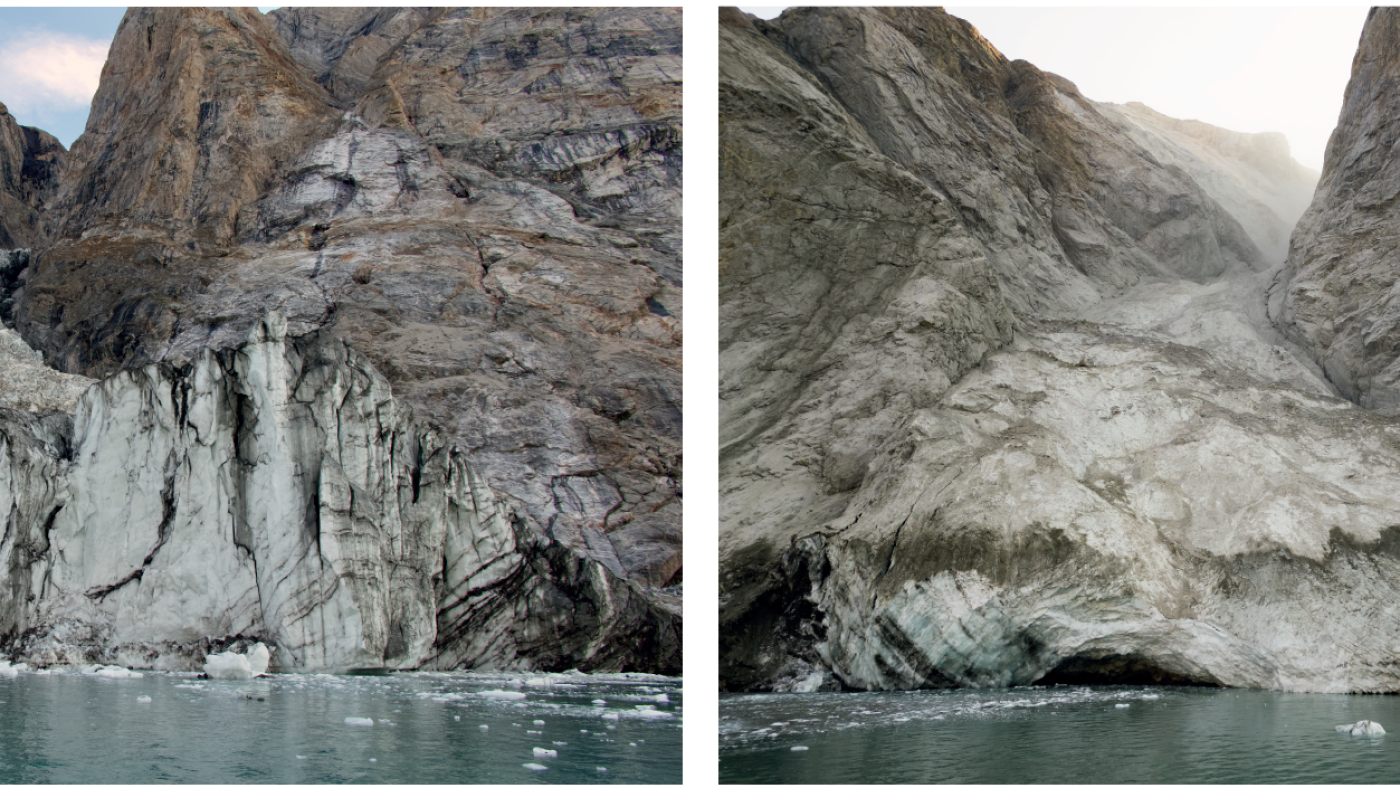
Images taken from Dickson fjord show before (August 2023) and after (September 2023) photos of the mountain peak and glacier where a large landslide triggered a tsunami.
Søren Rysgaard
hide caption
toggle caption
Søren Rysgaard
The global seismic signal was extremely unusual, and it resonated for more than a week. So it’s no surprise that it grabbed the attention of researchers around the world. In the end, it took 68 experts across 15 countries to figure out what caused the “USO,” or Unidentified Seismic Object, last September.
The USO label is “an informal term some seismologists use when they come across a seismic signal they can’t explain,” Kristian Svennevig, the lead author of a new report about the unusual signal, tells NPR.
As scientists studied the signal, one thing was certain from the start: it wasn’t caused by an earthquake.
“You can compare the vibrations from an earthquake to smashing your hands into a piano full force and removing them again,” setting off a cacophony of tones and sounds that decays fairly quickly, Svennevig says.
“The signal we describe is more like striking a single piano key for a very pure tone lasting for nine days.”
The signal was traced to a massive avalanche along the Dickson fjord in eastern Greenland, triggered by glacial melting due to climate change, according to research that Svennevig and nearly 70 co-authors published in the journal Science.
Some 1.2 kilometers (3/4 of a mile) above the remote fjord, a mountaintop collapsed, driving more than 25 million cubic meters of rock and ice into the water. The volume of material was enough to fill 10,000 Olympic-sized swimming pools, the researchers say.
The tsunami in question was towering: 200 meters — 656 feet — in height, according to the researchers. Because the wave’s energy was trapped in a rocky fjord, the water sloshed back and forth in a phenomenon called a seiche — and the scientists traced the seismic signal that was detected on sensors from the Arctic to Antarctica to that pattern.

Satellite images show a mountain top and glacier before and after a landslide.
Planet Labs satellite image
hide caption
toggle caption
Planet Labs satellite image
Their work toward an answer was slow, Svennevig says. Even when they gained an understanding of what likely happened, they needed more time and data to prove it.
“Only when we had access to declassified army bathymetrical mapping and had tweaked our tsunami models could we prove it through modelling: that part of the tsunami got caught between the parallel sides of the fjord and resonated for nine days,” he says.
The seiche was 7 meters tall and had a long duration, “with a frequency (11.45 millihertz) and slow amplitude decay that were nearly identical to the seismic signal” whose frequency was 10.88-millihertz as it oscillated roughly every 90 seconds, according to the article.
To the researchers, the signal was like an alarm bell — one that “rang” the Earth for nine days. Among the many wakeup calls humanity has gotten about the effects of climate change, they say, it’s one of the most striking yet. And they warn that we could see similar cascading events in the future.
“We may expect similar signals to occur if a landslide should happen in a similarly shaped fjord or lake,” Svennevig says. “We definitely expect the frequency of landslides and tsunamis to increase in the Arctic as a result of global warming.”
With the mystery of the global seismic signal solved, Svennevig says there is more work to be done to understand how the planet is adapting to climate change.
“There is a lot to learn from this event: Climate change is causing new natural phenomena we could not even dream of just a year ago,” he says. “There are still plenty of unresolved mysteries out there waiting for the next generation of geoscientists to unravel.”


